Holy Penmon
The 6th century saw a rise of the Christian Church throughout the Celtic world. This was accompanied by a growing tendency to form monasteries in remote places to follow ascetic lifestyles. During this time two monasteries were formed at opposite ends of Anglesey by two friends, Seiriol and Cybi. St. Cybi's monastery was at the heart of what is now Holyhead (its Welsh name, Caergybi, comes from the saint) and St. Seiriol set up in Penmon, at the northeast end of the island.
According to legend, the two saints used to meet weekly near Llanerchymedd, near the centre of the island. St. Cybi would walk from Holyhead, facing the rising sun in the morning and the setting sun in the evening. St. Seiriol, travelling in the opposite direction, would have the sun to his back during his journey. They were thus known as Cybi the Dark (since he was tanned during his journey) and Seiriol the Fair.
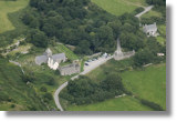
You can find the Penmon sites with this map or see an aerial view on Google Maps.
St. Seiriol's Well
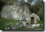
Penmon today has a range of interesting buildings. The oldest is most likely St. Seiriol's Well. Early Celtic churches were usually associated with a holy well. They were thought to have healing powers and were often visited by pilgrims. Baptisms also took place there. The belief in the power of the wells is probably carried over from the old pre-Christian Celtic religions.
St. Seiriol's Well is reached by walking up a path past a fish pond built by the monks. The well is enclosed within a small building, most of which is brick representing reconstruction in the 18th century; the flooring and lower parts of the wall are probably older. The foundations of another small building may be seen just next to the well (in the lower left of the picture above). This is popularly thought to be the remains of St. Seiriol's cell, where he would have lived, but there is no evidence to support this and its shape is not like other 6th century hermitages.
Penmon Priory
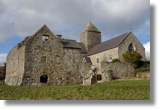
St. Seiriol's monastery developed throughout the centuries and by the 10th century it had a wooden church building and two high crosses that probably stood at the entrance to the monastic grounds. However, Viking raids in 971 destroyed the church. Rebuilding of the church in stone, giving the present building, took place throughout the 12th century during the prosperous period under the rule of Gruffudd ap Cynan and Owain Gwynedd. This is the most complete building of its age in northwest Wales.
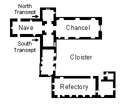
Plan of Penmon
The church is of the typical cruciform arrangement. The nave is the oldest part, finished about 1140. The transepts and the tower were built in 1160-70. The chancel (the rightmost part in the photo above) was added in 1220-1240 during the rule of Llywelyn AP Iorwerth (Llywelyn the Great). This occurred at the time when the king convinced the monasteries in North Wales to reorganize under the Augustine Order. Also built around this time was a refectory, with a large dining hall, cellars and a dormitory. This three story building is now roofless. The building between the refectory and the south transept was the prior's house, probably built in the 16th century. It is now a private dwelling. The area in the middle was the cloister, and there may at one time have been another building on the eastern side, enclosing the cloister.
The monastery was dissolved in 1537, during the reign of Henry VIII, along with most others in England and Wales. The lands then passed into the ownership of the local landowners, the Bulkeley family, and was used as a deer park. The church remained in use, however, and much of it was rebuilt in 1855.
High Crosses
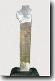
The two high crosses that graced the entrance to the early medieval monastery are still in existence and are now housed in the church. The larger cross (pictured to the left), which until 1977 stood in its original position in the deer park, is now in the nave. It is badly worn, but you can still just barely see the interlacing decorative patterns and a pictorial scene showing the temptation of St. Anthony, along with a probable hunting scene.
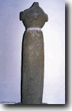
The smaller cross (pictured on the right), located in the south transept, is much less weathered. This is because it was once used as a lintel for one of the refectory windows; one of the arms of the cross was cut off for this use. The cross is mainly decorated with knotwork along with two animal heads on the sides. A baptismal font elsewhere in the church has similar patterns and may have been the original base of this cross; it now has a modern base.
Dovecot
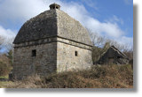
Sir Richard Bulkeley, who owned the old monastery lands after dissolution, probably built the dovecot that stands near the church, in about 1600. This was built to house domestic pigeons for their eggs and meat. This square building has a large domed roof with a small cupola on the top where the birds could fly in and out. Inside were 1000 nesting boxes to accommodate the doves. A pillar in the centre would have supported a revolving ladder to provide access to the boxes.
Puffin Island
When St. Seiriol founded the Penmon monastery he also set up a community on a small island just off the coast, 1/2 mile from the priory. This island is called Puffin Island in English but its Welsh name is Ynys Seiriol (Seiriol's Island). The Vikings called it Priestholm.
The island has a number of ruins of medieval monastic buildings, including the tower of a 12th century church. It is said that St. Seiriol himself is buried there, and perhaps also King Maelgwn Gwynedd, who was the ruler of North Wales and patron of St. Seiriol in setting up the religious community.
The island is mentioned by Gerald of Wales in his Journey through Wales in 1188. He notes that it was an ecclesiastical settlement at the time, "inhabited by hermits, living by manual labour and serving God". He also says that, according to legend, whenever there was strife within the community a plague of small mice would devour all their food.
A modern day plague of rats has also affected the island. As the name suggests, Ynys Seiriol once had large numbers of puffins as well as other seabirds such as guillemots. However, brown rats found their way to the island in 1890s, decimating the populations of nesting birds. At this time the puffin population was already declining because the birds had become a delicacy, but the rats further reduced their numbers to just 20 pairs a few years ago. In 1998 a program was begun by the Countryside Council for Wales to rid the island of the rats, in the hope of encouraging the birds to return.
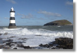
The sound between Puffin Island and Penmon Point (or Trwyn Du) is treacherous. A ship called the Rothesay Castle, on a day trip from Liverpool, sank here in 1831. A lighthouse (which can be seen in the above photograph) and a lifeboat station were built here soon after.
Also see:
Penmon Family history - Ken Davies' account of the history of his family from the Penmon area, including general history of the area.
View Churches and Chapels of Anglesey in a larger map
A new book by Warren Kovach, author of this web site
