
The Three Ages of Lligwy
The Lligwy region, near Moelfre, presents an interesting juxtaposition of ruins from three separate eras. As you drive down the narrow lane leading to the area, you pass a Neolithic burial chamber standing guard over Lligwy Bay. Go further and you reach a parking area overlooking the ruins of a medieval church. Then you can walk across the fields and through a small wood to walk through the gate of an ancient fortified homestead, last occupied 16 centuries ago.
You can find the Lligwy sites with this map or see the three sites on this Google Map. Aerial filming and 3d models of Din Lligwy and Capel Lligwy can be seen in this YouTube video.
Neolithic

This burial chamber dates back to the end of the 3rd millennium BC. As with other burial chambers like this, it would originally have been covered with a mound of earth or stone, with access to the central chamber through a small passage. The bones of the dead would then have been interred here. The Lligwy tomb is characterized by its massive capstone, weighing 25 tons.
This chamber was excavated in 1908, when the remains of 15-30 people were found. Along with them were pieces of beaker and grooved ware pottery that provide evidence for the age of this tomb. It is from the end of the Neolithic period and so was among the last of these types of tombs in use.
Roman Era
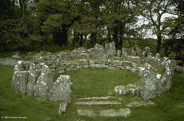
The Din Lligwy Hut Circle is an excellent example of a fortified hut group, dating from the latter days of the Roman occupation. Coins and pottery found here have been dated from the 4th century AD, although excavations and finds of earlier structures suggest that it was in use long before that. It is thought that the wall was built around the village at this time; the decline in the might of the Romans towards the end of their occupation meant that raids against villages became more commonplace.

The site covers half an acre and consists of the foundations of a number of buildings, with the entire area enclosed by a thick double wall, filled in with rubble. The size and shape of the buildings vary, suggesting different purposes. The round buildings are typical of iron age domestic dwellings, many of which are scattered around Anglesey. Excavations in the largest (pictured above and in the upper left corner of the plan) have found Roman coins, pottery and a glass jug as well as a silver ingot. This one is thought to have been the chieftain’s hut.
The rectangular building in the upper right was found to contain large amounts of metallic slag as well as remains of several hearths with charcoal formed from oak. It was evidently a workshop for the smelting and working of iron. The entrance to the fortified compound was through a rectangular building at the right in the diagram above. The village’s livestock would have been housed in this building.
An aerial view of the site can be seen on Google Maps.
Read more about Din Lligwy in my article for Nation.Cymru
Medieval

The 12th century saw the cessation of Viking raids on Anglesey and, as a result, increasing prosperity and stability. At this time many of the old Celtic churches, originally built with timber, were replaced by stone buildings. Hen Capel Lligwy (Old Lligwy Chapel) is one of these.
Nothing is known of the history of this church, so we do not know to which saint it was dedicated. But its position, on a lonely hillside overlooking Lligwy Bay (and, on a clear day, the Isle of Man) and lying near to Din Lligwy, means that this is an evocative site.
The building, now roofless, was originally built in the 12th century, but the upper parts of the walls were reconstructed in the 14th century. A small chapel, with a crypt underneath, was added in the 16th century.
The sight of this church, standing on its own far from any dwellings, must leave the visitor wondering why it was built in such an isolated place. It is common on Anglesey to see these 12th and 13th century churches far from settlement, or perhaps just next to a single farm (usually named something like Ty’n-llan, which means “farm by the church”). However, its isolation probably has more to do with changing population patterns than any desire for solitude on the part of the churchmen. It is very likely that the church would have been the only stone building, and thus the only one to survive when a village was abandoned due to depopulation and consolidation of communities. Thus Capel Lligwy was once probably the centre of a sizeable community, perhaps formed around the nucleus of the Din Lligwy farmstead.
View all Anglesey Churches & Chapels on Google Maps